Acquiring the soil stratification of soda saline-alkali soils using ground penetrating radar
-
摘要:
东北松嫩平原西部地区苏打盐碱地面积巨大并且改良难度大,严重制约着当地农业生产力的发展。快速了解土体中的土壤层次信息对于评价、改良与利用盐渍化土壤具有重要意义。该研究以位于吉林西部松嫩平原的典型苏打盐碱地为研究对象,利用探地雷达对不同盐碱程度的盐碱土进行野外探测,分别基于雷达图像波形图和Hilbert谱瞬时属性确定土壤分层时域位置,并采用扩展后的Dobson介电常数模型估算各层介电常数,从而获得土壤分层厚度信息,最后将两种方法检测结果与实地挖掘剖面进行对比分析。结果表明:1)土壤盐分含量对探地雷达信号的影响十分明显,大于7 ns时,电磁波幅值已很小。苏打盐碱土介电常数仍主要由实部决定,但介电常数虚部不能被忽略;2)基于雷达图像波形图和基于Hilbert谱瞬时属性两种方法均可较为准确地识别耕层(Ap)时域位置,但由于电磁波能量的衰减,基于波形图像的方法无法识别耕层以下层次,而基于Hilbert谱瞬时相位方法除个别过渡层外,可准确识别60 cm内绝大多数土壤层次;3)除个别过渡层外,基于Hilbert谱瞬时相位方法获得的土层厚度绝对误差基本在5 cm以内,相对误差在15%以内,基本能满足盐碱地野外探测需求。Hilbert谱瞬时相位对盐碱地探地雷达信号具有明显增强作用,有助于客观识别土壤分层时域位置,该研究可为快速、无损获取盐渍化土壤层次信息提供借鉴。
Abstract:A large area of soda saline-alkali soil has seriously restricted the local agricultural productivity in the western Songnen Plain of Northeast China. The soil layers can also dominate the movement of water and salt in soil. It is of great significance to rapidly obtain the stratification in this area, in order to evaluate and improve the soda saline-alkali soils. Taking the typical saline-alkali soils in this area as the research object, this study aims to acquire the soil stratification using ground penetrating radar. Firstly, the soda saline-alkali soils with different salt contents were selected to conduct the ground penetrating radar (GPR) detection experiment. Then, the time domain location of stratification was then determined by radar image waveform and Hilbert spectrum instantaneous attributes. In waveform diagram of radar image, multi-point single channel waveform diagrams were combined with the radar time profiles. The soil layering was then determined as the time domain position in the overall soil layer division of the studied plot. The "three instantaneous" attributes of radar signals (instantaneous amplitude, frequency, and phase) were compared to determine the soil layering, according to Hilbert spectral instantaneous attributes. As such, the multi-point instantaneous phase maps and profiles were combined to determine the time domain position of the overall soil layer division in the studied plot. Then, the dielectric constant of each soil layer was calculated using the extended Dobson dielectric constant model. The propagation velocity of electromagnetic wave was estimated in each soil layer, according to the dielectric constant. The thickness of each soil layer was calculated to combine the time domain position of the soil layer. Finally, the field excavation profile was compared after data acquirement. The stratification of the field excavation profile was also evaluated by the soil classification experts, according to the visual and tactile characteristics of the soil. The results indicated that: 1) The content of soil salinity shared a significant impact on the ground penetrating radar signal. There was the very small amplitude of electromagnetic wave, when the two-way travel of GPR exceeded 7 ns. 2) Both radar image waveform and Hilbert spectral instantaneous attributes were accurately identified the time domain position of the plow layer (Ap). However, the waveform failed to recognize the layers below the plow layer, due to the attenuation of electromagnetic wave energy. On the contrary, the Hilbert spectral instantaneous phase was accurately identified the most soil layers within 60 cm, except for a few transition layers; 3) The absolute and relative errors of soil thickness were basically within 5 cm, and 15%, respectively, using Hilbert spectrum instantaneous phase and real soil profile. The performance was fully met the needs in the field exploration of saline-alkali land. This finding can provide a strong reference for the rapid and nondestructive access to the salinized soil layers.
-
-
![]()
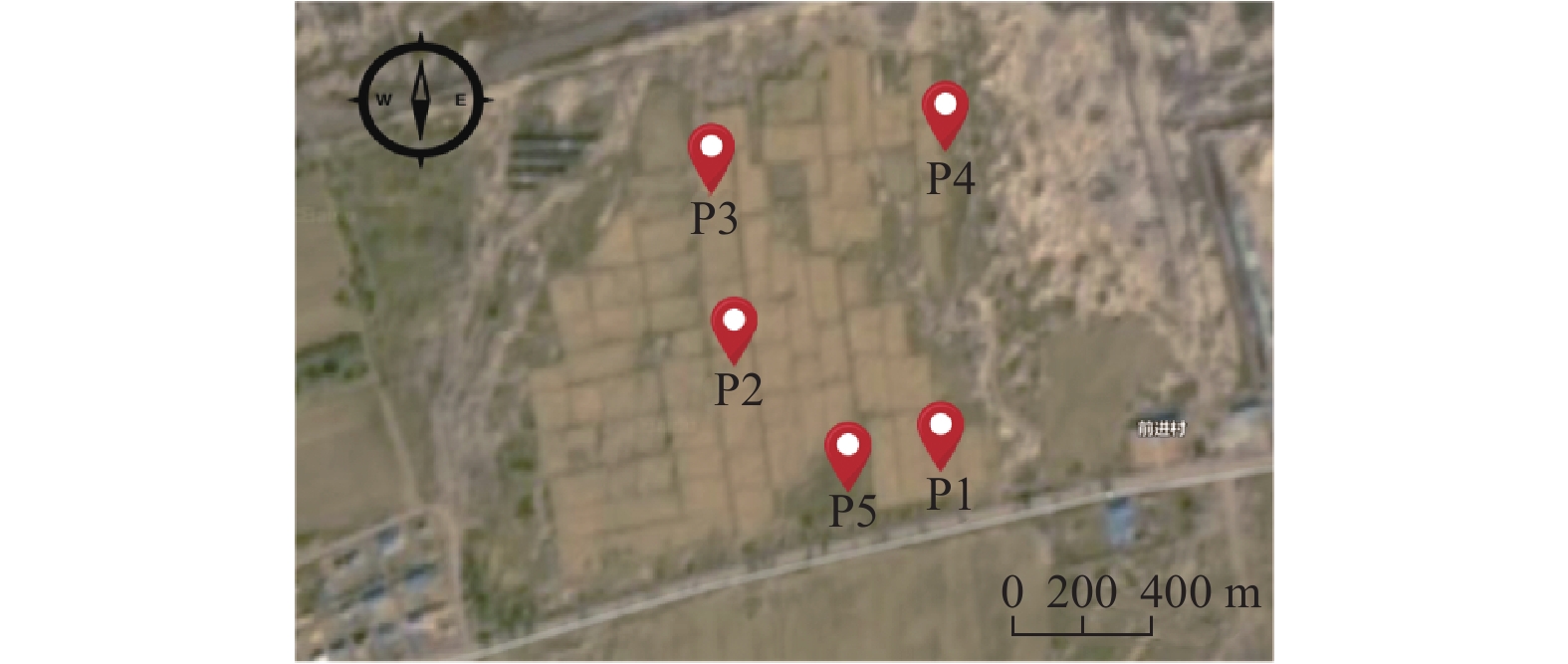
图 1 苏打盐碱地采样点分布图
注:P1样地为轻度盐碱土,P2~P5样地为中重度盐碱土。
Figure 1. Sampling locations in soda saline-alkali soil area
Note: P1 plot is mild saline alkali soil, and P2~P5 plots are moderate to severe saline alkali soil.
![]()
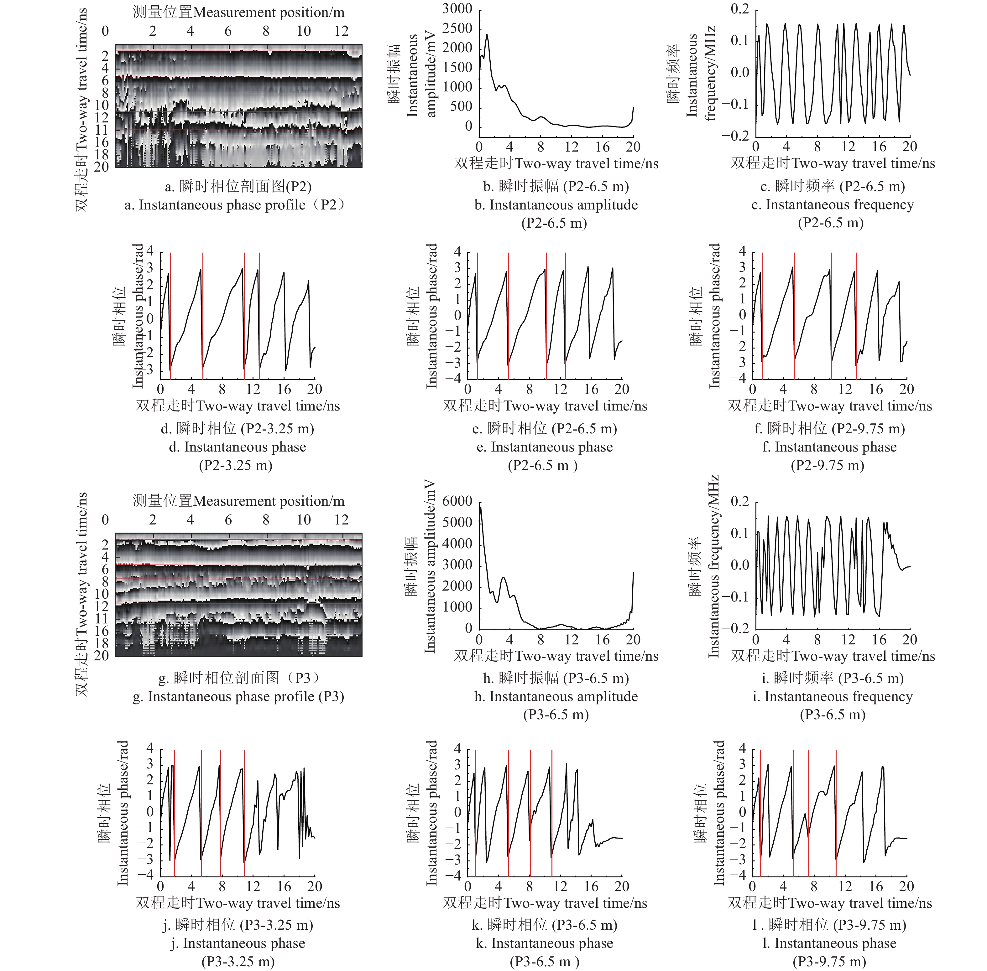
图 3 基于雷达图像波形图的土壤分层识别结果
注:红线代表识别的土壤分层时域位置,下同。
Figure 3. Soil layer identification results based on GPR waveform image
Note: The red line represents the time-domain position of soil stratification, the same as below.
![]()
图 4 基于雷达Hilbert谱瞬时属性的土壤分层识别结果
Figure 4. Soil layer identification results based on instantaneous parameters of GPR Hilbert spectrum
表 1 各采样点土壤剖面层次信息
Table 1 Stratified information of all soil profiles
样地
Sample plot发生层
Soil horizon深度
Depth/
cm根系
Root质地
Texture容重
Bulk density/
(g·cm−3)pH值
pH value含水率
Water content/%含盐量
Salt content/
(g·kg−1)电导率
Conductivity/
(mS·cm−1)粒径占比
Proportion of particle size/%介电常数
Dielectric
constant介电常数
Dielectric constant砂粒Sand 粉粒Silt 黏粒Clay 实部
Real part虚部
Imaginary partP1 Ap 0~22 多量 砂质黏壤 1.53 8.37 14.38 2.28 0.41 52.77 9.15 38.08 6.16 0.55 6.18 ACz1 22~32 少量 砂质壤土 1.61 8.65 15.59 0.37 0.24 59.38 10.43 30.19 6.73 0.48 6.75 ACz2 32~53 无根系 砂质壤土 1.67 9.51 16.05 1.50 0.34 56.15 15.38 28.47 6.96 0.47 6.98 P2 Ap 0~20 中量 砂质黏壤 1.54 9.96 14.25 10.30 1.15 73.00 5.50 21.50 7.46 1.25 7.56 ACz 20~53 极少量 砂质黏壤 1.75 10.26 17.95 14.78 1.56 59.60 11.10 29.30 8.33 1.40 8.45 C 53~71 无根系 砂质黏壤 1.74 10.18 19.63 11.89 1.29 57.30 16.40 26.30 9.22 1.33 9.32 P3 Ap 0~22 多量 砂质黏壤 1.40 9.29 14.18 9.74 1.10 46.70 19.60 33.70 7.20 1.32 7.32 ABz 22~32 少量 砂质黏壤 1.73 10.24 18.18 15.73 1.65 59.20 10.70 30.10 7.76 1.45 8.01 Bz 32~59 无根系 砂质黏壤 1.65 10.36 20.45 21.73 2.20 63.90 3.70 32.40 8.66 1.98 8.78 P4 Ap 0~32 多量 砂质黏壤 1.45 9.40 23.07 5.21 0.68 69.40 0.40 30.20 8.83 1.02 8.49 ABz 32~62 极少量 砂质壤土 1.68 10.21 24.07 12.77 1.38 61.90 18.10 20.00 9.02 2.05 9.25 P5 Ab 0~25 中量 砂质黏土 1.63 10.10 24.07 12.35 1.34 53.80 11.00 35.20 9.53 1.90 9.72 ABz 25~54 极少量 壤土 1.65 10.32 24.16 15.67 1.64 48.20 36.80 15.00 10.36 2.12 10.58  下载: 导出CSV
表 2 探地雷达探测分层厚度与实测厚度对比
Table 2 Comparison of soil layer thickness between GPR detection and actual measurement
样地
Sample
plot土壤分层
Soil
horizon实测分层
厚度
Measured layer
thickness/cm探地雷达判读层次厚度
GPR interpretation layer thickness误差分析
Error analysis基于雷达波形图方法
Method based on radar waveform基于Hilbert谱瞬时相位方法
Method based on instantaneous
phase of Hilbert spectrum基于雷达波形图方法
Method based on radar waveform基于Hilbert谱瞬时相位方法
Method based on instantaneous
phase of Hilbert spectrum双程走时
Two-way travel
time/ns计算值
Calculated
value/cm双程走时
Two-way travel
time/ns计算值
Calculated
value/cm绝对误差
Absolute
error/cm相对误差
Relative
error/%绝对误差
Absolute
error/cm相对误差
Relative
error/%P1 — 0 1.85 1.95 Ap 22 5.02 17.12 6.35 23.76 4.88 22.18 −1.76 8.00 ACz1 10 — — — — — — — — ACz2 21 — — 11.72 28.99 — — −7.99 38.05 P2 — 0 1.05 1.15 Ap 20 5.15 20.91 5.32 21.27 −0.91 4.55 −1.27 6.35 ACz 33 — — 10.83 28.10 — — 4.90 14.85 C 18 — — 13.92 16.69 — 1.31 7.28 P3 — 0 1.02 1.05 Ap 22 5.05 20.75 5.08 20.75 1.25 5.68 1.25 5.68 ABz 10 7.02 10.14 7.73 13.64 −0.14 1.40 −3.64 36.40 Bz 27 — — 11.82 22.09 — — 4.91 18.19 P4 — 0 1.08 1.06 Ap 32 6.25 27.91 6.72 30.56 4.09 12.78 1.44 4.50 ABz 30 — — 12.85 33.1 — — −3.10 10.33 P5 — 0 1.16 1.17 Ab 25 6.87 30.83 6.02 26.19 −5.83 23.32 −1.19 4.76 ABz 29 — — 10.52 24.30 — — 4.70 16.21
下载: 导出CSV
-
[1] WEI Y, LI LH, HU WJ, et al. Suppression of rice blast by bacterial strains isolated from cultivated soda saline-sodic soils[J]. International Journal of Environmental Research and Public Health, 2020, 14(17): 5248-5248.
[2] 孙广友,王海霞. 松嫩平原盐碱地大规模开发的前期研究、灌区格局与风险控制[J]. 资源科学,2016,38(3):407-413. SUN Guangyou,WANG Haixia . Large scale development to saline-alkali soil and risk control for the Songnen Plain[J]. Resources Science,2016,38(3):407-413. (in Chinese with English abstract)
[3] 李秀军,李取生,王志春,等. 松嫩平原西部盐碱地特点及合理利用研究[J]. 农业现代化研究,2002,23(5):361-364. doi: 10.3969/j.issn.1000-0275.2002.05.010 LI Xiujun, LI Qusheng, WANG Zhichun, et al. Characteristics and rational utilization of saline alkali land in the Western Songnen Plain[J]. Research on Agricultural Modernization, 2002, 23(5): 361-364. (in Chinese with English abstract) doi: 10.3969/j.issn.1000-0275.2002.05.010
[4] 李取生,李秀军,李晓军,等. 松嫩平原苏打盐碱地治理与利用[J]. 资源科学,2003,25(1):15-20. LI Qusheng, LI Xiujun, LI Xiaojun, et al. Treatment and utilization of soda saline alkali land in Songnen Plain [J]. Resource Science, 2003, 25(1): 15-20. (in Chinese with English abstract)
[5] HAN X L, LIU J T, ZHANG J, et al. Identifying soil structure along headwater hillslopes using ground penetrating radar based technique[J]. Journal of Mountain Science, 2016, 13(3): 405-415. doi: 10.1007/s11629-014-3279-7
[6] HOU J S, YAN Y Q, CONG P T. Application of technology of UAV-Mounted ground penetrating radar in the study of the thickness of soil plow layer[C]// Proceedings of the 7th International Conference on Environmental Science and Civil Engineering, IOP, 2021: 2387-2394.
[7] ZHANG X L, DAO L G, ZHANG C S, et al. Mapping the spatial distribution of soil depth in a grassland ecosystem with the aid of ground penetrating radar and GIS[J]. Grassland Science, 2018, 64(4): 217-225. doi: 10.1111/grs.12201
[8] JOL H M, BRISTOW C S, FISHER I E, et al. Ground penetrating radar: theory and applications[M]. UK: Elsevier Science, 2009: 4-4.
[9] JOHNSON R W, GLACCUM R, WOJTASINSKI R. Application of ground penetrating radar to soil survey[J]. Soil and Crop Science Society of Florida Proceedings, 1982, 23(3): 17-17.
[10] SHIH S F, DOOLITTLE J A. Using radar to investigate organic soil thickness in the Florida Everglades[J]. Soil Science Society of America Journal, 1984, 48(3): 651-656. doi: 10.2136/sssaj1984.03615995004800030036x
[11] DAVIS J, ANNAN A. Ground-penetrating radar for high-resolution mapping of soil and rock stratigraphy[J]. Geophysical Prospecting, 1989, 37(5): 531-551. doi: 10.1111/j.1365-2478.1989.tb02221.x
[12] COLLINS M E, SCELENTRAGER G W, DOOLITLE J A, et al. Using ground-penetrating radar to study changes in soil map unit composition in selected histosols[J]. Soil Science Society of America Journal, 1986, 50(2): 408-412. doi: 10.2136/sssaj1986.03615995005000020030x
[13] TINA W, BENTE S M, DENNIS W, et al. What Is Beyond Hyperbola Detection and Characterization in Ground-Penetrating Radar Data?-Implications from the Archaeological Site of Goting, Germany[J]. Remote Sensing, 2024, 16(21): 4080-4080.
[14] ROTH K, WOLLSCHLAGER U, CHENG Z H, et al. Exploring soil layers and water tables with ground-penetrating radar[J]. Pedosphere, 2004, 14(3): 273-282.
[15] 薛建,曾昭发,田刚,等. 探地雷达在吉林西部地区探测土壤碱化层[J]. 物探与化探,2005,28(5):421-424. XUE Jian, ZENG Zhaofa, TIAN Gang, et al. The application of GPR to detecting the saline−alkali layer in west Jilin[J]. Geophysical & Geochemical Exploration, 2005, 28(5): 421-424. (in Chinese with English abstract)
[16] 王升,陈洪松,付智勇,等. 基于探地雷达的典型喀斯特坡地土层厚度估测[J]. 土壤学报,2015,52(5):1024-1030. WANG Sheng, CHEN Hongsong, FU Zhiyong, et al. Estimation of thickness of soil layer on typical karst hillslopes using a ground penetrating radar[J]. Acta Pedologica Sinica, 2015, 52(5): 1024-1030. (in Chinese with English abstract)
[17] 曹棋,宋效东,杨顺华,等. 基于探地雷达的典型红壤区网纹红土层识别[J]. 土壤学报,2019,56(4):813-824. CAO Qi, SONG Xiaodong, YANG Shunhua, et al. Identification of plinthitic red earth layers in red soil regions typical of south china with ground penetrating radar[J]. Acta Pedologica Sinica, 2019, 56(4): 813-824. (in Chinese with English abstract)
[18] 宋文,张敏,吴克宁,等. 潮土区农田土体构型层次的探地雷达无损探测试验[J]. 农业工程学报,2018,34(16):129-138. doi: 10.11975/j.issn.1002-6819.2018.16.017 SONG Wen, ZHANG Min, WU Kening, et al. Test on nondestructive detection of farmland solum structure in fluvo-aquic soil area using ground penetrating radar[J]. Transactions of the Chinese Society of Agricultural Engineering, 2018, 34(16): 129-138. (in Chinese with English abstract) doi: 10.11975/j.issn.1002-6819.2018.16.017
[19] 李光辉,马嘉辉,王哲旭,等. 基于深度神经网络的探地雷达杂波抑制和根参数预测方法[J]. 农业工程学报,2023,39(16):171-180. LI Guanghui, MA Jiahui, WANG Zhexu, et al. Suppressing ground penetrating radar clutter to predict root parameters using deep neural networks[J]. Transactions of the Chinese Society of Agricultural Engineering (Transactions of the CSAE), 2023, 39(16): 171-180. (in Chinese with English abstract)
[20] 张海如,王国富,张法全. 联合瞬时参数分析用于探地雷达目标增强[J]. 微波学报,2017,33(1):16-20. ZHANG Hairu, Wang Guofu, ZHANG Faquan. Conjoin instantaneous parameters analysis for GPR targets enhancement[J]. Journal of Microwaves, 2017, 33(1): 16-20. (in Chinese with English abstract)
[21] 李俐,付雪,崔佳,等. 基于包络检波和STFT谱分析的探地雷达土壤分层信息识别[J]. 地球信息科学学报,2020,22(2):316-327. LI Li, FU Xue, CUI Jia, et al. Soil layer identification based on envelope detector and STFT spectrum analysis of ground penetrating radar signals[J]. Journal of Geo−information Science, 2020, 22(2): 316-327. (in Chinese with English abstract)
[22] 吴全,姚喜军,陈晓东,等. 基于探地雷达的土体构型无损探测方法研究[J]. 干旱区地理,2022,45(6):1860-1869. WU Quan, YAO Xijun, CHEN Xiaodong, et al. Nondestructive inspection method for soil profile configuration based on ground penetrating radar[J]. Arid Land Geography, 2022, 45(6): 1860-1869. (in Chinese with English abstract)
[23] RUAN W M, LIU B J, LIU H J, et al. Ground Penetrating radar (GPR) identification method for agricultural soil stratification in a typical mollisols area[J]. Chinese Geographical Science, 2023, 33(4): 664-678. doi: 10.1007/s11769-023-1358-9
[24] DOOLITTLE J A, MINZENMAYER F E, WALTMAN S W, et al. Ground-penetrating radar soil suitability map of the conterminous United States[J]. Geoderma, 2007, 141: 416-421. doi: 10.1016/j.geoderma.2007.05.015
[25] 李彬,王志春,迟春明. 吉林省大安市苏打碱土含盐量与电导率的关系[J]. 干旱地区农业研究,2006(4):168-171. doi: 10.3321/j.issn:1000-7601.2006.04.036 LI Bin, WANG Zhichun, CHI Chunming. The relationship between salt content and electric conductivity of soda solonetz in Da’an City[J]. Agricultural Research in the Arid Areas, 2006(4): 168-171. (in Chinese with English abstract) doi: 10.3321/j.issn:1000-7601.2006.04.036
[26] REYNOLDS, JOHN M. An Introduction to Applied and Environmental Geophysics[M]. 2nd ed. New Jersey, USA: Wiley-Blackwell, 2011: 4-4.
[27] 胡庆荣. 含水含盐土壤介电特性实验研究及对雷达图像的响应分析[D]. 北京:中国科学院研究生院(遥感应用研究所),2003:99-100. HU Qingrong. Studies on Mierowave Dieleetric Behavior of Moist Salt Soil and Its Effect on Backscattering Coefficients Extracted From Radar Image[D]. Beijing: Graduate Universtity of Chinese Academy of Sciences (Institute of Remote Sensing Applications), 2003:99-100. (in Chinese with English abstract)
[28] 张金珠,邹 杰,王振华,等. 利用 GPR 多频天线振幅包络平均值法估算滴灌棉田土壤盐分含量[J]. 农业工程学报,2021,37(8):99-107. doi: 10.11975/j.issn.1002-6819.2021.08.011 ZHANG Jinzhu, ZOU Jie, WANG Zhenhua, et al. Estimation of soil salt content in drip irrigation cotton field using GPR multi-frequency antenna amplitude envelope average method[J]. Transactions of the Chinese Society of Agricultural Engineering (Transactions of the CSAE), 2021, 37(8): 99-107. (in Chinese with English abstract) doi: 10.11975/j.issn.1002-6819.2021.08.011
[29] 田玉福,窦森,张玉广,等. 暗管不同埋管间距对苏打草甸碱土的改良效果[J]. 农业工程学报,2012,29(12):145-153. TIAN Yufu, DOU Sen, ZHANG Yuguang, et al. Improvement effects of subsurface pipe with different spacing on sodic-alkali soil[J]. Transactions of the Chinese Society of Agricultural Engineering (Transactions of the CSAE), 2012, 29(12): 145-153. (in Chinese with English abstract)
[30] YELF R. Where is true time zero? [C]// Proceedings of the Tenth International Conference on Grounds Penetrating Radar. Netherlands, Delft: IEEE, 2004: 279-282.
[31] WANG P, LI X J, MIN X Y, et al. Investigating soil layers with ground penetrating radar in the modern Yellow River Delta of China[J]. Near Surface Geophysics, 2024, 22(3): 339-357.
[32] 程琦, 叶回春, 董祥林, 等.采用探地雷达频谱分析的复垦土壤含水率反演[J]. 农业工程学报,2021, 37(6): 108-116. CHENG Qi, YE Huichun, DONG Xianglin, et al. Inversion of reclaimed soil moisture based on spectrum analysis of ground penetrating radar[J]. Transactions of the Chinese Society of Agricultural Engineering (Transactions of the CSAE), 2021, 37(6): 108-116. (in Chinese with English abstract)
[33] TOPP GC, DAVIS JL, ANNAN AP. Electromagnetic determination of soil water content: measurement in coaxial transmission lines[J]. Water Resource Research, 1980(3): 574-582.
[34] ROTH C H, MALICKIM A, PLAGGE R. Empirical evaluation of the relationship between soil dielectric constant and volumetric water content as the basis for calibrating soil moisture measurements by TDR[J]. Journal of Soil Science, 1992, 43(1): 1-13.
-
期刊类型引用(12)
1. 李朝清,谭兴强,李吉,李毅,周艺璇. 基于改进LoFTR算法的草畜平衡监测图像拼接方法. 农业与技术. 2025(06): 65-70 .  百度学术
百度学术
2. 苑朝,黄诺飞,蒋阳,赵亚冬,赵振兵. 基于改进旋转不变性二进制描述算法的电力场景图像拼接. 电力科学与工程. 2024(01): 31-38 . 百度学术
3. 许鑫,张力,岳继博,钟鹤鸣,王颖,刘杰,乔红波. 农田环境下无人机图像并行拼接识别算法. 农业工程学报. 2024(09): 154-163 . 本站查看
4. 刘媛媛,孙宇,高雪冰,王利斌,王跃勇,刘梦琪,崔舒然. 航拍多光谱田间秸秆覆盖量反演模型的建立与优化. 光学精密工程. 2024(11): 1773-1787 . 百度学术
5. 马小娅. 基于局部精细拼接算法的无人机图像处理技术分析. 佳木斯大学学报(自然科学版). 2024(06): 41-44 . 百度学术
6. 刘明,李永可,靳晟,李悦,余恩. 基于无人机摄影技术的农田场景可视化系统设计与实现. 湖北农业科学. 2024(08): 158-163 . 百度学术
7. 何佳. 基于人工智能的光学表面疵病图像自动化拼接研究. 自动化与仪表. 2024(09): 61-65 . 百度学术
8. 潘维东,李安虎,刘兴盛. 基于区域优化的图像拼接技术研究及应用进展. 激光与光电子学进展. 2024(18): 1-20 . 百度学术
9. 郑蔚. 基于SIFT-GMLBP的动态图像视觉信息提取研究. 现代电子技术. 2024(19): 83-86 . 百度学术
10. 李易达,王雨欣,李晨曦,赵冀,马恢,张漫,李寒. 融合改进头脑风暴与Powell算法的马铃薯多模态图像配准. 农业工程学报. 2024(19): 146-158 . 本站查看
11. 陈颖博. 基于深度学习的桑叶成熟度智能识别. 农业与技术. 2024(24): 56-59 . 百度学术
12. 齐咏生 ,焦杰 ,鲍腾飞 ,王朝霞 ,杜晓旭 . 基于自适应注意力机制的复杂场景下牛脸检测算法. 农业工程学报. 2023(14): 173-183 . 本站查看
其他类型引用(15)


计量
- 文章访问数: 125
- HTML全文浏览量: 8
- PDF下载量: 33
- 被引次数: 27